How Real Time Data Reduces Urban Traffic Jams Fast
10 min read Explore how real-time data technologies swiftly alleviate urban traffic congestion, transforming city commuting with dynamic solutions and cutting-edge innovations. (0 Reviews)
How Real Time Data Reduces Urban Traffic Jams Fast
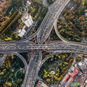
Urban traffic congestion is a growing challenge worldwide, costing billions in lost productivity, increased emissions, and commuter stress. Traditional traffic solutions often lag, responding too slowly or relying on outdated data. However, the integration of real-time data has revolutionized urban traffic management, enabling cities to address snarls and gridlocks instantaneously. This article delves deep into how real-time data functions, the technologies involved, and powerful examples of cities rapidly easing traffic gridlock for smoother, safer mobility.
The Urban Congestion Crisis: Why Traditional Methods Fall Short
Today’s metropolitan areas host millions of vehicles daily. Traffic jams are a stark indicator of urban dysfunction, increasing fuel consumption and urban pollution. According to the INRIX Global Traffic Scorecard 2023, drivers in the US lost an average of 65 hours annually in traffic congestion, costing about $3,400 per driver. Traditional traffic management — reliant on scheduled signal timings or periodic traffic counts — is inherently reactive and often based on historic data that cannot accurately predict sudden disruptions.
This lag creates cascading delays, exacerbating rush hours, emergency vehicle response times, and freight logistics. Simply put, the roads become overwhelmed because the systems managing them don’t respond swiftly to real-world, minute-to-minute situations.
What is Real-Time Traffic Data?
Real-time traffic data refers to instantaneous, continuously updated information about vehicle presence, speeds, congestion spots, road incidents, and travel times collected from various sources:
- GPS and Smartphone Data: Aggregated GPS traces from smartphones, navigation apps like Google Maps or Waze, and connected vehicle sensors.
- Traffic Cameras and Sensors: Inductive loop detectors, infrared sensors, and CCTV cameras embedded on roads and intersections.
- Crowdsourced Reports: User-submitted data on accidents, stalls, or road conditions through mobile apps.
- Public Transit and IoT Systems: Data from buses, trams, and smart traffic lights.
Putting this diverse data together allows traffic control systems and navigation platforms to perceive actual traffic conditions as they unfold.
How Real-Time Data Tackles Urban Traffic Congestion
Dynamic Traffic Signal Optimization
Real-time traffic volumes feed adaptive traffic signal systems, dynamically changing green light durations and sequences based on current demand. For example, cities like Los Angeles employ the Automated Traffic Surveillance and Control (ATSAC) system that analyzes real-time inputs from thousands of intersections. Result: congestion reductions of up to 12% during peak hours and faster emergency responses.
Key benefits:
- Minimized idling time at intersections
- Prioritized travel routes for buses and emergency vehicles
- Reduced stop-and-go waves that create bottlenecks
Real-Time Traffic Routing and Navigation
Apps like Waze and Google Maps utilize crowdsourced and sensor data to offer drivers optimal alternate routes, avoiding jammed corridors. Toyota’s Mobility Services Platform integrates vehicle data for real-time routing adjustments, reducing average trip times by 20%.
Example: In cities where real-time navigation tools are widely used, localized jams dissipate as vehicles redistribute, smoothing traffic flow.
Incident Detection and Quick Response
Real-time monitoring enables rapid identification of accidents or stalled vehicles, alerting dispatch to clear blockages before they escalate into long queues. In Singapore, the Land Transport Authority’s Expressway Monitoring and Advisory System (EMAS) has significantly lowered response times, decreasing secondary crashes and congestion severity.
Intelligent Parking Solutions
Finding parking creates significant urban congestion—with estimates suggesting up to 30% of inner-city traffic is due to vehicles circulating searching for spots. IoT-enabled sensors communicate parking availability in real-time directly to drivers via apps, reducing unnecessary driving and curbside congestion.
Integration with Public Transit Systems
Real-time data synchronizes vehicle flow with public transportation schedules. For instance, adaptive traffic signals grant priority to approaching buses, improving schedule reliability and encouraging public transit use, which takes cars off the road.
Real-World Success Stories
Los Angeles, USA
LA’s ATSAC, implemented in the 1980s, continuously upgrades to incorporate real-time sensing. Managed by over 4,500 signalized intersections, ATSAC has saved motorists billions of hours and reduced emissions by optimizing green wave patterns in downtown corridors.
Stockholm, Sweden
Stockholm’s congestion tax integrates real-time traffic data to dynamically adjust charges and traffic flows. During peak congestion periods, the system adjusts tolling and reroutes to alleviate pressure, resulting in a 20% traffic volume reduction immediately post-implementation.
Seoul, South Korea
Seoul’s Traffic Management Center uses AI-enabled real-time surveillance cameras and sensor data to predict looming congestion and modulate traffic signals. This proactive management has reduced travel delays by more than 15% despite high urban density.
Bangalore, India
Addressing chronic congestion, Bangalore introduced smart traffic lights linked with GPS data from public buses and police patrol vehicles. This system reduce peak hour waiting times by 25%, improving average speeds on main corridors.
Emerging Technologies Enhancing Real-Time Traffic Control
Artificial Intelligence and Machine Learning
AI models analyze historical and real-time data to predict congestion before it happens, offering preemptive interventions like rerouting and signal adjustments. Machine learning continually refines these predictions based on new traffic patterns.
5G and Edge Computing
The rollout of 5G networks drastically reduces latency for data transmission between vehicles, sensors, and traffic control centers. Edge computing processes data locally “on the edge,” enabling instant traffic decisions rather than relying exclusively on centralized cloud systems.
Connected and Autonomous Vehicles (CAVs)
CAVs communicate with each other and infrastructure, sharing real-time travel status to coordinate speeds and routes. Their widespread adoption promises near-elimination of human-caused traffic inefficiencies.
Big Data Analytics and Predictive Traffic Management
Massive datasets from cities can be leveraged to uncover hidden traffic patterns and weekday/weekend behavioral trends — informing strategic infrastructure investments and scheduling.
Challenges and Considerations
While real-time data brings remarkable benefits, cities face challenges:
- Data Privacy and Security: Ensuring anonymization and protection of driver and citizen data.
- Infrastructure Costs: Upgrading sensors, cameras, and computational infrastructure can be capital intensive.
- Integration Complexity: Combining data from myriad providers and legacy systems requires significant coordination.
- Equity Issues: Ensuring technology benefits do not disproportionately favor affluent neighborhoods or commuters.
Thoughtful policy, public-private partnerships, and community engagement are critical to overcoming these challenges.
Conclusion: A Traffic Revolution Powered by Data
The fusion of real-time data with cutting-edge technologies offers unprecedented tools to combat the age-old problem of urban traffic jams. Cities embedding real-time monitoring, predictive analytics, and adaptive control systems are unleashing faster, cleaner, and less frustrating commutes.
From Los Angeles to Seoul, success stories prove these solutions are not just theoretical but practical and scalable globally. As 5G, AI, and connected vehicles become mainstream, the potential for instantaneous, city-wide traffic harmony grows ever closer. Urban mobility is evolving — and real-time data sits at the heart of this transformative revolution.
For city leaders, planners, and commuters alike, embracing real-time data-driven traffic management represents a clear path to safer streets, healthier environments, and more productive lives.
References:
- INRIX 2023 Global Traffic Scorecard
- Los Angeles ATSAC official reports
- Singapore Land Transport Authority publications
- Stockholm congestion tax impact studies
- Seoul Metropolitan Government Traffic Center data
- IEEE Transactions on Intelligent Transportation Systems
Rate the Post
User Reviews
Other posts in Urban Planning


Popular Posts