
Behind the Scenes The Data Driving Urban Design Decisions in 2024
8 min read Explore how data shapes urban design decisions in 2024, revolutionizing cities with smarter, sustainable solutions. (0 Reviews)
Behind the Scenes: The Data Driving Urban Design Decisions in 2024
Urban design has never been more dynamic or data-driven than it is in 2024. Behind every thoughtfully crafted public space, sustainable infrastructure project, or transportation hub lies a treasure trove of data reshaping how cities evolve. As populations surge and environmental challenges mount, leveraging data isn’t just innovative—it’s essential.
In this article, we dive deep into the unseen layers of data analytics and technologies transforming urban design decisions worldwide. From sensor networks and AI modeling to community-generated data, we uncover how cities are becoming smarter and more responsive.
The Rise of Data-Driven Urban Design
Previously reliant on historical patterns and qualitative assessments, urban design in 2024 thrives on quantitative, real-time, and predictive data. For city planners and architects, the shift means access to unprecedented detail and granularity, transforming broad-stroke concepts into precise interventions.
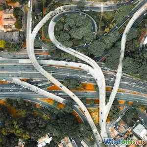
Consider Singapore’s Urban Redevelopment Authority (URA). It employs a vast network of IoT sensors collecting data on foot traffic, air quality, noise levels, and energy usage. This continuous feedback loop enables iterative design tweaks to maximize public space efficiency and livability.
The power of such data integration was highlighted by URA’s recent project: redesigning a congested interchange using dynamic pedestrian flow data. By analyzing peak usage times and movement patterns, planners reduced bottlenecks and improved safety through targeted widening of walkways and repositioning street furniture.
Key Data Sources Driving Design Decisions
1. Sensor Networks and Internet of Things (IoT)
IoT devices are foundational for real-time data acquisition. Sensors embedded in streetlights, benches, and transportation systems continuously track metrics such as:
- Pedestrian and vehicle counts
- Environmental quality (air, noise, temperature)
- Infrastructure health and usage
For instance, Barcelona’s Smart City initiative collects granular environmental data to adjust green space irrigation schedules, ensuring resource preservation without compromising urban greenery.
2. Geographic Information Systems (GIS) and Spatial Data
GIS aggregates geographical, demographic, and environmental data layers. This multidimensional mapping helps designers visualize space utilization patterns and environmental impact.
New York City’s Department of City Planning uses GIS-based analyses to prioritize equitable access to parks by overlaying population density, median income, and existing green space locations. This data-driven approach targets funding to underserved neighborhoods effectively.
3. Big Data & AI-Driven Predictive Models
Massive datasets fed into advanced AI algorithms empower designers to simulate urban scenarios under varying conditions—traffic surges, weather events, or new developments.
A prime example is Helsinki’s use of machine learning models to optimize the public transit network. Simulations based on real ridership and traffic data have helped reduce wait times by an average of 20%, significantly enhancing commuter satisfaction.
4. Community-Sourced Data and Social Media Analytics
Engaging citizens directly through apps and social platforms provides qualitative insights about user experiences, preferences, and emerging needs.
The city of Amsterdam embraces a "Participatory Sensing" program where residents upload data related to noise pollution and public space usage. This democratized data influences iterative urban improvements aligning with community priorities.
Data-Driven Urban Design in Action: Case Studies
Seoul’s Revival of Public Spaces
Seoul integrated data from mobile devices, CCTV cameras, and transport sensors to combat urban congestion and enhance public safety. By analyzing crowd densities and movement flows, the city redesigned plazas to prevent overcrowding during events without sacrificing social interaction opportunities.
Copenhagen’s Climate Resilience Plan
In response to rising sea levels and rainwater flooding, Copenhagen uses hydrological sensors and predictive modeling to guide infrastructure upgrades. Its urban design incorporates green roofs and permeable pavements selectively placed where data indicates highest flood risks.
This precise targeting avoids overbuilding and optimizes budget allocation for climate adaptive infrastructure.
Challenges of Data-Driven Urban Design
Despite its benefits, reliance on data presents challenges:
- Data Privacy: Collecting continuous data can infringe on personal privacy if not managed transparently and ethically.
- Data Silos: Fragmented data across agencies or incompatible formats can hinder integrated decision-making.
- Technical Complexity: Interpreting massive datasets requires specialized skills and resources that some municipalities lack.
Addressing these concerns requires robust governance frameworks and public-private collaborations to maintain trust and maximize utility.
The Future Outlook: Towards Smarter, Human-Centric Cities
In 2024, urban design’s data revolution is still unfolding. Emerging advances like 5G and edge computing will increase sensor network reliability and data processing speed, enabling real-time design interventions.
Moreover, integrating augmented reality (AR) for public feedback will allow residents to visualize changes before implementation, increasing participatory planning.
As Michael Kimmelman, architecture critic for The New York Times, notes: “Cities of the future must not only be smart but wise—turning data into empathy, building environments where technology serves people and planet alike.”
This balance between technology and human values will define the next generation of urban spaces.
Conclusion
Data is the invisible yet powerful force driving urban design in 2024. By merging technology, analytics, and community input, cities worldwide craft adaptive, sustainable environments ready to confront complex challenges.
Successful urban design today goes beyond form and function: it is an ongoing, data-informed dialogue between nature, infrastructure, and inhabitants. To everyone passionate about shaping better cities, embracing this data-driven approach is not optional but imperative.
Next time you stroll through a thoughtfully designed urban park or navigate a streamlined transit hub, remember that behind those decisions lies a wealth of data—and a vision for smarter, more livable cities.
References:
- Singapore Urban Redevelopment Authority Official Website
- Barcelona Smart City Initiative Reports, 2023
- New York City Department of City Planning – GIS Data Use Case Studies
- Helsinki Regional Transport Authority 2023 Annual Report
- Amsterdam Participatory Sensing Project Documentation
- Copenhagen Climate Adaption Strategy 2024
- Kimmelman, M. (2023). The Wisdom of Smart Cities. The New York Times.
Rate the Post
User Reviews


Popular Posts