How Kenya Fights Poaching with Technology and Community Guides
33 min read How Kenya blends drones, GPS collars, and Maasai community scouts to stop poaching, protect elephants and rhinos, and grow livelihoods through data-driven patrols and early-warning systems. (0 Reviews)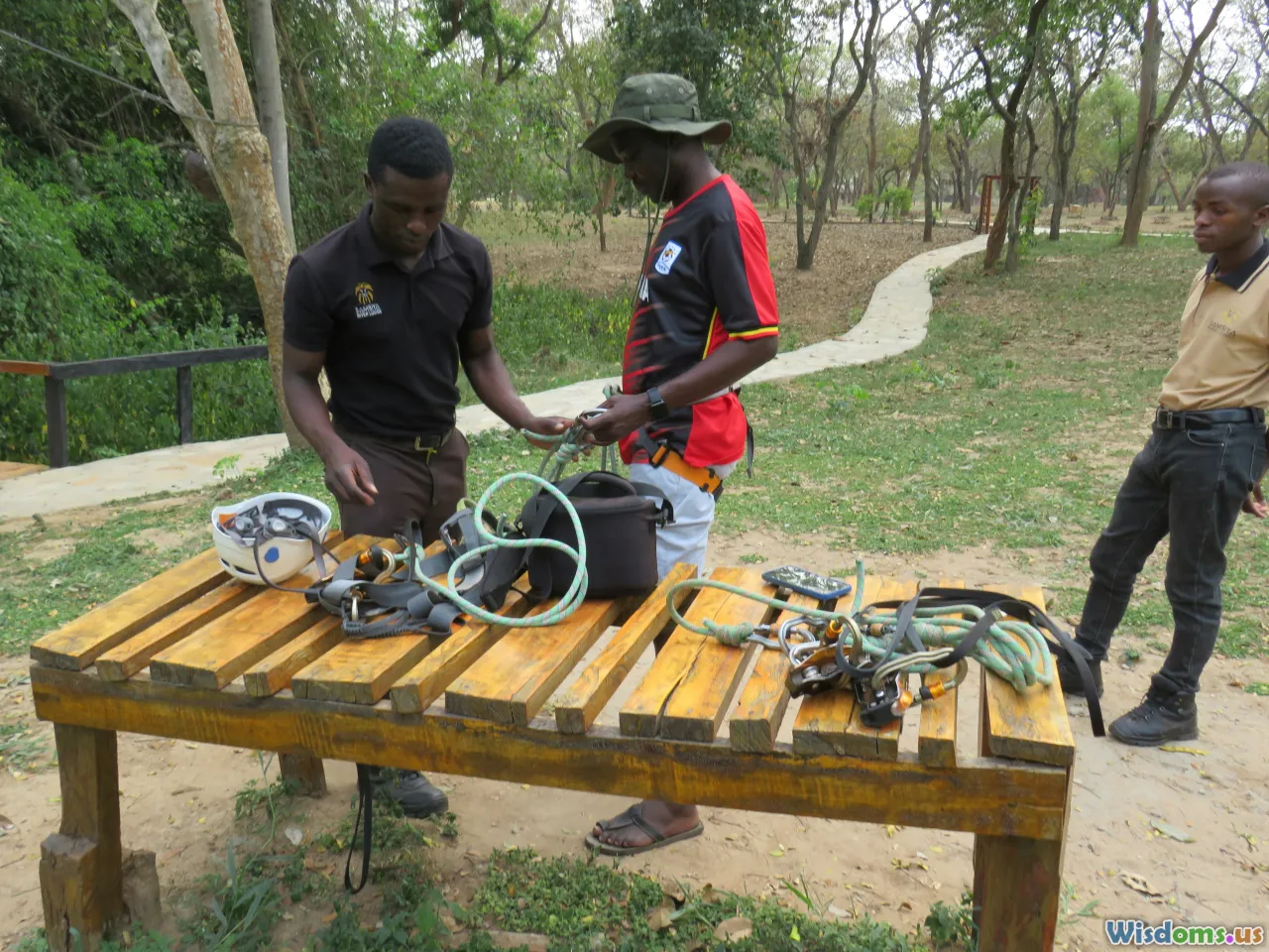
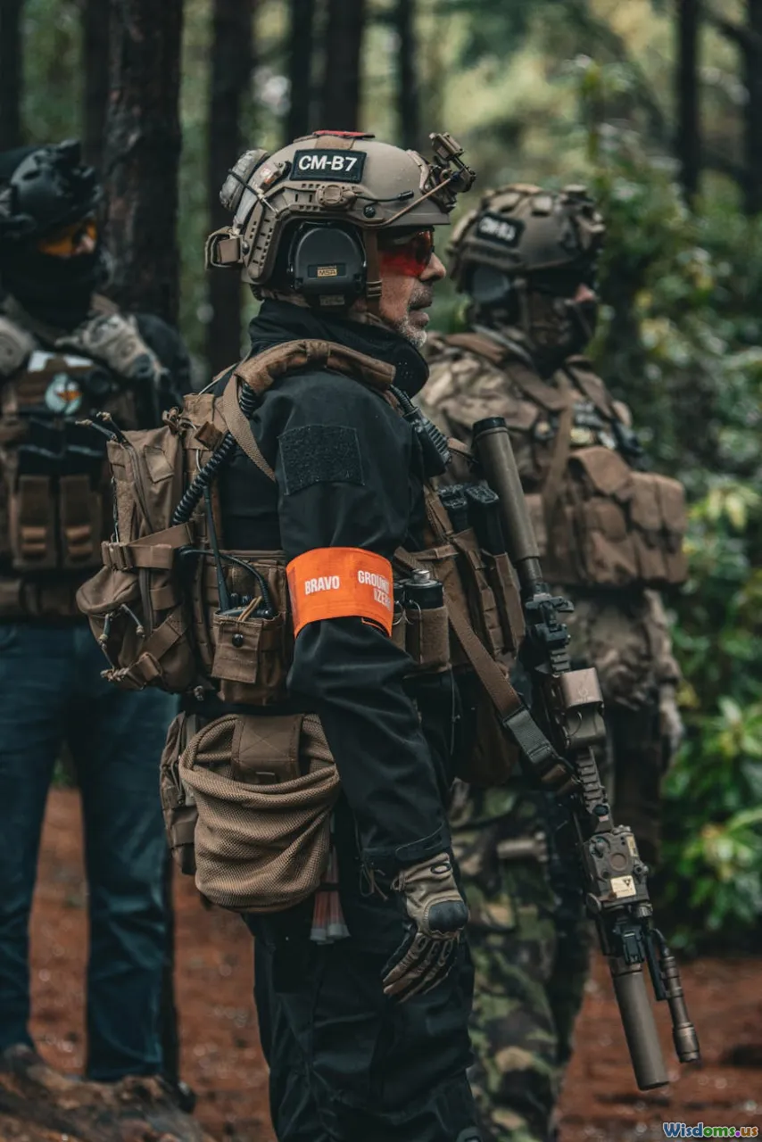
Before sunrise on a windswept escarpment above the savanna, a radio crackles and a small operations room comes to life. A big screen shows dots moving across a digital map: collared elephants hugging a riverine corridor; ranger patrols fanning out; a fence line flashing yellow where a geofence alert just triggered. Across the room, a community guide—born and raised in a nearby village—checks his phone. An SMS tip from a herder about suspicious motorbikes has come in, already synchronized to the map. A drone team stands by with a thermal camera. Twenty minutes later, a patrol intercepts the bikes and finds snares. No shots fired, no animals harmed. In Kenya, this blend of technology and community intelligence is turning the tide against poaching—and changing how conservation works.
The Stakes and the Shift: From Reactive Patrols to Data-Driven Protection

For decades, anti-poaching efforts in Kenya were built on courage, endurance, and luck. Rangers walked long distances, followed tracks, and reacted to incidents after the fact. That approach did save wildlife, but it was slow and expensive—and poachers became increasingly sophisticated, exploiting gaps in coverage and using vehicles, radios, and night-time operations.
The last ten years have marked a decisive shift:
- Real-time situational awareness platforms now fuse patrol data, animal locations, and incident reports into a single map that informs every decision.
- Community conservancies have expanded dramatically, turning neighbors into stewards and first responders.
- Tougher penalties and specialized investigators, canine units, and forensic labs extend the fight beyond the bush to supply chains, ports, and courts.
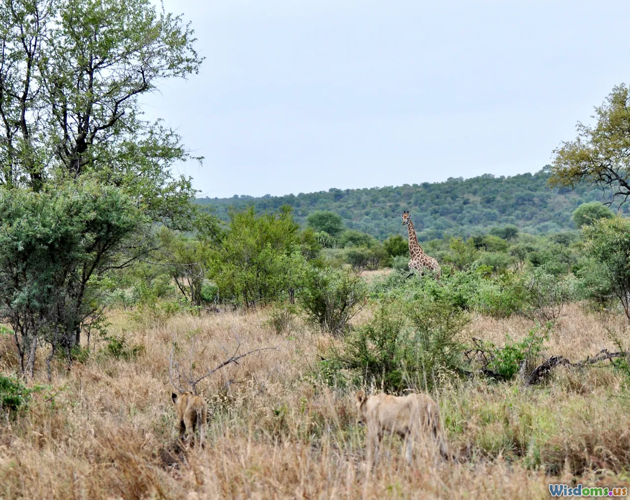
This new model correlates with measurable gains. Kenya’s elephant numbers rebounded to more than 36,000 by 2020 after steep losses earlier in the 2000s, and rhino poaching has fallen to rare events, including years with zero rhinos poached. Hard work, better laws, and stronger technology have combined with local leadership to produce results that are felt both in protected areas and across the wider landscape.
Real-Time Eyes and Ears: EarthRanger, SMART, and CyberTracker in the Field

In Kenya, digital conservation often starts with three tools that talk to each other:
- SMART (Spatial Monitoring and Reporting Tool): rangers use rugged smartphones to log patrols, snares removed, and wildlife sightings, even offline. SMART Connect syncs data to a central server where analysts can spot patterns and plan deployments.
- EarthRanger: a real-time command-and-control platform developed with conservation partners that ingests collar positions, camera trap alerts, radio logs, and tips. When a geofence is breached or a panic button is pressed, EarthRanger can ping the closest unit and track the response.
- CyberTracker: a field-proven app that lets rangers tap icon-based forms to record standardized observations quickly. Data flows into SMART and, increasingly, to EarthRanger.
Concrete examples across Kenya:
- Lewa Wildlife Conservancy and the adjacent Borana Conservancy pioneered an integrated operations room that monitors collared rhinos and elephants alongside ranger patrols. If a collared animal stops moving or breaks a geofence at night, a rapid response team is dispatched.
- Ol Pejeta Conservancy uses EarthRanger to coordinate wildlife security and human-wildlife conflict responses, with inputs from fences, vehicle trackers, and community hotlines.
- Northern Rangelands Trust (NRT), a network of more than 40 community conservancies covering tens of thousands of square kilometers, runs multiple operations centers that aggregate ranger patrols and incident reports in real time, enabling mutual aid across conservancy boundaries when a pursuit crosses a river or county line.
Actionable advice for teams starting out:
- Standardize data early. Agree on patrol forms, incident categories, and GPS coordinate formats to prevent “data debt.”
- Appoint a duty controller. One person per shift should own the radio, the dashboard, and the logbook, ensuring no alert is lost.
- Close the loop daily. Every event on the map should end with an outcome note—arrest, negative search, or false alarm—so you can evaluate patterns honestly.
Night is No Advantage: Drones, Thermal Cameras, and Smart Lighting

Poachers have long relied on darkness for cover. In response, Kenyan conservancies have built capable night operations that use aerial and ground-based sensors.
- Small UAVs with thermal cameras: Teams launch permitted drones at dusk to scan fence lines and water points. Warm-blooded silhouettes are easy to spot against cool ground in the early night. In open savanna, a small drone can clear hundreds of hectares in minutes.
- Fixed thermal cameras at choke points: Some conservancies install pan-tilt-zoom thermal cameras near perimeters and river crossings. These feed back to EarthRanger, where motion analytics highlight suspicious movement so the duty controller can direct patrols.
- Smart lighting and silent mobility: Red-lens torches preserve night vision. Electric motorbikes reduce noise, making it easier to approach without spooking wildlife or tipping off suspects.
Practical tips:
- Don’t overfly the same routes. Rotate patterns to avoid becoming predictable to watchers who might be scouting your routines.
- Fly low-risk missions. Keep drones for detection and overwatch; avoid chasing suspects from the air, which can be dangerous and rarely succeeds.
- Align with regulations. Kenya’s drone rules require permits and coordination with the Kenya Civil Aviation Authority; conservancies work under approved operations manuals, designated pilots, and clearly defined airspace.
Real-world impact: At several northern conservancies, thermal drones have helped intercept motorbikes carrying snares before they reached rhino zones. Handovers are coordinated by radio, with the drone maintaining overwatch while patrols close in on waypoints shared by the controller.
Collars, Geofences, and Humane Tracking of High-Risk Species
Tracking collars aren’t just for science; they’re frontline security tools when deployed ethically.
- Elephants: The Mara Elephant Project and partners have collared dozens of elephants in conflict-prone corridors. When a herd heads toward farms at night, the operations room sends a community guide team with spotlights and vehicle horns to gently turn them back. Alerts help avoid dangerous confrontations and de-escalate crop-raiding.
- Rhinos: Only a subset of rhinos carry transmitters (to protect redundancy and avoid creating single points of failure). Geofencing creates virtual boundaries around safe areas. If a rhino approaches a risk zone at night, a discreet patrol shadows it until daylight.
Best practices for humane tracking:
- Collar sparingly. Tag only sentinel animals in key herds or those that are habitually at risk, to minimize handling and avoid overexposure of data.
- Encrypt and compartmentalize. Only essential staff see real-time positions; sensitive coordinates are never shared publicly.
- Time-bound data access. Researchers get de-identified datasets on delay, while security teams receive live feeds.
What about connectivity? In remote areas, satellite IoT tags and LoRa repeaters can bridge gaps where cellular networks fail, delivering updates every few minutes to an hour—fast enough to guide patrols but slow enough to conserve battery and bandwidth.
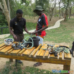
Community Guides at the Center: Scouts, Ilchokuti, and Trusted Networks

Technology reduces response time, but human relationships prevent the need for force. In Kenya’s conservancies, community guides—often called scouts, or ilchokuti in parts of the Mara—serve as cultural translators, first responders, and informants.
What they do:
- Walk and talk. Scouts patrol with rangers but also spend hours in villages, building trust with elders and herders, mediating grazing access, and explaining why certain areas are sensitive.
- De-escalate conflicts. When elephants approach crops, community teams coordinate with families, use vehicle headlights, and guide animals along known paths back to wild areas.
- Gather critical tips. Through community meetings, WhatsApp groups, and hotlines, guides hear about snares, gunshots, or new faces buying meat. Anonymous tips often trigger the earliest alerts.
Kenyan examples:
- In the Amboseli ecosystem, hundreds of community rangers supported by organizations like Big Life Foundation work shoulder-to-shoulder with Kenya Wildlife Service (KWS) officers and National Police Reservists. Their community credibility is as important as their fieldcraft.
- Across NRT conservancies, locally recruited scouts paired with GPS-enabled radios and smartphones feed patrol logs into SMART while liaising with grazing committees. The same person who notes a fresh footprint also knows which herders crossed where, and why.
Actionable insights for NGOs and conservancies:
- Recruit locally, promote from within. Pay fairly and offer training and promotions. A respected scout is your best sensor.
- Create non-cash recognition. Certificates, public acknowledgements, and opportunities to train elsewhere can matter as much as stipends.
- Protect sources. Use anonymous tip lines and clear confidentiality protocols to safeguard informants.
Mobile Money and Micro-Incentives: Fast, Transparent Community Payments

Kenya’s ubiquitous mobile money (M-Pesa) is a quiet superpower in anti-poaching. It enables:
- Rapid reimbursements to scouts for fuel and emergency responses.
- Stipends to community informants, with transaction records supporting audit trails.
- Conditional payments to community groups for meeting conservation goals—like zero snaring incidents in a zone for a month.
Implementation tips:
- Pre-approve vendors. Register fuel stations and trusted mechanics to prevent cash leakage.
- Use unique reference codes. Every payment should tie back to an incident ID or patrol operation number.
- Set caps and alerts. Automated daily limits per phone reduce fraud risks and trigger reviews for anomalous spending.
These micro-incentives don’t replace salaries or core budgets; they smooth the friction of running 24/7 operations and align the community’s interest with wildlife outcomes.
Dogs, Labs, and the Long Arm of Enforcement

Stopping poachers is only half the job. To deter the crime, Kenya has strengthened the chain from field to courtroom.
- Canine units at airports and roadblocks: At Jomo Kenyatta International Airport (JKIA), Mombasa Port, and inland checkpoints, trained dogs sniff out ivory, rhino horn, bushmeat, and firearms. Handlers keep meticulous logs, and canine hits often lead to broader investigations of trafficking networks.
- Wildlife forensics: Kenya Wildlife Service’s forensic and genetic labs in Nairobi process DNA from rhino horn and ivory to link seizures to carcasses or geographic origins. Kenyan cases also draw on regional systems like the Rhino DNA Index System (RhODIS) and global reference databases that can match tusk DNA to poaching hotspots.
- Digital chain of custody: From scene-of-crime kits to tamper-evident bags and barcoded evidence logs, modern case files include photos, GPS coordinates, timestamps, and signed witness statements.
Casework matters because Kenya’s Wildlife Conservation and Management Act (2013) carries stiff penalties, including fines reaching into tens of millions of Kenyan shillings and potential long prison terms for killing endangered species. A well-documented case is the difference between a slap on the wrist and a landmark conviction.
Ports, Borders, and the Supply Chain Analytics that Catch Traffickers

Much ivory and wildlife contraband moves through maritime containers or air cargo. Kenya has invested in risk-based screening to increase the odds of intercepts without slowing legitimate trade.
- Container profiling at Mombasa: Customs data, routing anomalies, and known high-risk commodities feed models that flag shipments for scanning. Inspectors look for misdeclared timber or stone that hides ivory.
- Air cargo checks at JKIA: X-ray scanners, canine sweeps, and targeted inspections focus on shipments to high-risk destinations. Small parcels are screened for false bottoms and dual-use packaging.
- Intelligence sharing: KWS collaborates with customs, police, and regional and international networks to track entities, phone numbers, and shipping agents linked to prior seizures.
Actionable steps for enforcement agencies:
- Build a joint tasking calendar. Weekly meetings align port, customs, and wildlife priorities and allocate limited scanners and canine teams to the highest-risk shipments.
- Use feedback loops. When a flagged container turns out clean, analysis should refine the model; when contraband is found, features like exporter history and misdeclared codes are added to the watchlist.
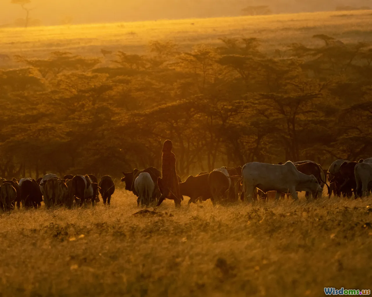
Community Conservancies and the Economics of Choosing Wildlife
Technology won’t stop poaching if the economics favor illegal hunting. Kenya’s community conservancy model changes the math by giving residents legal rights and revenue streams tied to healthy wildlife.
What a conservancy offers:
- Governance: Elected boards draw up grazing plans, approve budgets, and resolve conflicts. Transparency builds trust.
- Jobs: Scouts, rangers, guides, mechanics, and hospitality workers earn stable incomes tied to conservation.
- Revenue sharing: Tourism concessions, bed-night fees, and—more recently—carbon credits provide cash to community projects like schools, clinics, and water points.
Northern Rangelands Trust conservancies exemplify this approach, coordinating grazing across vast rangelands so grass recovers and wildlife returns. During the tourism slump of the pandemic, carbon finance from landscape-scale rangeland management created a financial lifeline that kept rangers paid and patrols running. When people see reliable benefits, snaring declines and tip-offs increase.
Practical guidance for starting a conservancy:
- Map rights and use. Clarify land tenure and collective agreements before signing leases with lodges. Ambiguity kills projects.
- Publish the budget. Post revenues and expenditures on noticeboards and WhatsApp groups. Sunlight discourages elite capture.
- Invest in coexistence. Predator-proof bomas, water infrastructure, and grass banks reduce conflicts that might otherwise lead to retaliatory killing or tolerance for poachers.
Reducing Human-Wildlife Conflict with Simple Tech: SMS, Beehives, and Chili

Poaching often spikes where people feel wildlife is a threat. Kenya’s conflict-mitigation playbook blends tradition and tech:
- SMS and app alerts: When elephant collars show a herd approaching fields, automated text alerts go to nearby households and community response teams. Families can move children indoors and prepare non-lethal deterrents.
- Beehive fences: Elephants dislike bees. Stringing beehives along a farm boundary creates both a living alarm and a honey income stream.
- Chili and light barriers: Chili-greased rope fences, flashing lights, and reflective tape can deter night crop-raids for a fraction of the cost of permanent fencing.
These tools dramatically reduce the anger and loss that feed sympathy for poachers. Every conflict avoided is one less reason for a farmer to look the other way when strangers offer cash for bushmeat.
Policy Teeth: Laws, Stockpile Burns, and Inter-Agency Coordination

Few interventions reshape incentives like credible law. Kenya’s 2013 Wildlife Act ushered in a new era of accountability, increasing fines and jail terms for serious wildlife crimes. Specialized prosecution units improved case handling, while courts grew more familiar with scientific evidence.
Symbolic acts reinforced the message. The burning of large ivory stockpiles in Nairobi sent a clear signal that Kenya would not profit from dead elephants—and won’t be a laundering route for contraband.
Cooperation is crucial. KWS works with county governments, police, prosecutors, and intelligence services to run joint operations, share equipment, and streamline responses. A notorious poacher no longer faces a patchwork of jurisdictions; he faces a networked state.
Measuring Impact Without Fooling Yourself

Tech makes measurement easier, but it also increases the risk of misreading the dashboard. Smart teams in Kenya use a set of sober metrics:
- Detection effort: patrol hours, area covered, and camera-days, to normalize incident counts.
- Incident types and outcomes: snares removed, shots heard, arrests made, with timelines to case closure.
- Wildlife trends: births, mortalities, collar survival, and distribution shifts, triangulated with aerial counts where possible.
- Community indicators: tip volume, conflict incidents, and survey-based trust scores.
Avoid common mistakes:
- Don’t conflate arrests with impact. A spike in arrests may reflect better intelligence, not more crime—or vice versa.
- Look for displacement. If poaching drops inside a conservancy, check neighboring areas. Success must scale beyond your fence.
- Share methods, not just wins. Publishing protocols allows peer review and learning.
A Practical Blueprint: Building a Kenya-Style Anti-Poaching System

If you’re tasked with designing a program, here’s a step-by-step approach distilled from Kenyan practice:
- Assemble the core team
- Duty controller per shift, with decision authority.
- Field operations lead, canine lead (if available), and a data officer.
- Community liaison officer embedded in village governance.
- Choose the tech stack
- Field data: SMART with CyberTracker on rugged Androids, with SMART Connect for sync.
- Command layer: EarthRanger or equivalent for real-time visualization.
- Radios and repeaters: VHF for voice; consider digital for encryption.
- Sensors: start with a few GPS collars, a handheld thermal monocular, and one small drone.
- Hardwire procedures
- SOPs for geofence alerts, drone launches, canine deployments, and evidence handling.
- Duty logs that reconcile radio traffic, dashboard alerts, and field outcomes each day.
- Rules of engagement that prioritize de-escalation and safety.
- Secure data and permissions
- Access tiers (controller, ranger, researcher) with need-to-know permissions.
- Data retention schedules and anonymization for research releases.
- Signed MOUs with government on data-sharing and jurisdiction.
- Invest in community partnerships
- Recruit and train community scouts with clear career paths.
- Establish hotlines, tip rewards, and confidentiality safeguards.
- Fund coexistence infrastructure: bomas, water points, grazing plans.
- Close the loop and iterate
- Weekly debriefs with maps on the wall to review hotspots.
- Monthly metrics dashboards with targets.
- Annual external audit of both finances and program outcomes.
Pitfalls and Safeguards: What Kenya Teaches About Doing It Right

- Privacy and safety: Real-time animal locations are sensitive. If leaked, they can enable crime. Limit live data to trusted personnel and audit access logs.
- Tech lock-in: Start with interoperable tools and open standards. Avoid proprietary hardware that can’t export data or integrate with your command platform.
- Drone overreach: Drones can alarm communities and wildlife. Keep use surgical and permitted; pair with community briefings to maintain trust.
- Ranger wellbeing: Burnout is real. Rotations, trauma support, and life insurance are as essential as fuel and radios.
- Maintenance budgets: Batteries, collars, and cameras fail. Budget 10–20% of capital cost per year for maintenance and replacements.
Case Snapshots: How the Pieces Work Together
-
Snares on the river: A community informant texts a hotline about two men carrying wire and sacks at dusk. The message auto-creates an event in EarthRanger. The controller assigns the closest community scout team, which approaches on foot while a small drone scans downstream. Thermal imagery picks up a heat signature near a thicket. Rangers recover 30 snares, no confrontation necessary.
-
Crop-raiding herd near a school: A collared matriarch triggers a geofence alert. SMS warnings go to nearby homes. Community guides arrive with flashlights and coordinate with the school watchman. A vehicle convoy with headlights nudges the herd toward a safe corridor. No crops trampled, no shots fired.
-
Suspicious shipment: Risk analytics flag a container loaded as “timber” by a newly formed exporter. Canine sweep hits on the second row. X-ray shows irregular shapes. Inside, inspectors find ivory hidden in hollowed logs. DNA samples go to the lab, linking the consignment to carcasses from a neighboring country and enabling a broader investigation.
Each episode demonstrates the same choreography: human relationships trigger tips, technology speeds detection and coordination, and professionalized enforcement makes consequences real.
Choosing the Right Drones, Cameras, and Collars: A Field Buying Guide

- Drones: Look for quiet propellers, 30+ minutes flight time, thermal resolution at least 640×512, and zoom optics for ID. Carry spare batteries and a strobe for night navigation. Train two pilots to avoid single-point failure.
- Thermal optics: A handheld monocular can transform night patrols for a fraction of a drone’s cost. Prioritize wide field-of-view for scanning.
- GPS collars and tags: For elephants, ensure drop-off mechanisms and veterinary support. For rhinos, consider horn-embedded transmitters only where vetted and legal, with strict secrecy of IDs.
- Communications: Redundant charging—solar plus generator—keeps comms online. In hilly conservancies, install repeaters and test dead zones monthly.
Data Governance and Ethics: A Simple Policy You Can Adopt Tomorrow

- Purpose limitation: We collect real-time animal and patrol data solely for protection and conflict mitigation.
- Access control: Live positions restricted to operations staff. Researchers receive de-identified data on at least a 24–72 hour delay.
- Consent and context: Communities are briefed on what’s collected and why. Tipsters choose anonymous or named channels.
- Security: Devices use strong passcodes; servers implement role-based access and multi-factor authentication.
- Retention: Raw real-time data retained for 12 months, then archived. Evidence records follow legal requirements.
- Oversight: A quarterly committee with community, ranger, and NGO representation reviews data use and complaints.
The Next Frontier: Smarter Alerts, Satellites, and eDNA—Without the Hype

- Edge AI on camera traps: Modern traps can run simple models to filter out wind and livestock, sending alerts only for humans at night or vehicles in restricted zones. This saves bandwidth and reduces false alarms for controllers.
- Satellite sensing: High-resolution imagery and radar can map new tracks or small clearings after rains, revealing potential access routes. Night-time lights analysis can highlight new fishing camps or charcoal kilns that correlate with poaching pressure.
- eDNA forensics: Environmental DNA in waterholes can confirm presence of rare species without disturbance. In enforcement, minute DNA traces on tools or clothing can tie suspects to carcasses when paired with a reference database.
Guardrails:
- Test before scaling. Pilot in one sector, measure false positives, and adapt forms and workflows.
- Keep humans in the loop. Alerts cue decisions; they don’t replace them. A veteran scout’s judgment is still the best filter.
What Success Feels Like on the Ground
By late afternoon, the heat lifts and wind combs the grass. A community meeting breaks up under an acacia tree: grazing plans agreed, a school roof funded, and a predator-proof boma scheduled for a family that lost a calf last week. Radios buzz as patrols check in, their GPS tracks already syncing to the dashboard. On the ridge, the duty controller logs the day’s last incident: “False alarm—bushbuck.” A collared elephant cluster turns away from a farm after a community guide waves a torch and shouts into the dark.
In Kenya, these steady, unremarkable moments add up to something remarkable. Technology shrinks distance and time; community guides turn data into trust; laws and labs keep promises real. The animals don’t know about dashboards or policies. They know quiet nights, safe water, and corridors that still lead to dawn. That is the point of all the gear and planning: to make space for life to move unharmed. And when a radio crackles at 3 a.m., someone will be awake, map glowing, ready to answer.
Rate the Post
User Reviews


Popular Posts